Genetic geography in colour

Explore population structure across places and scales.

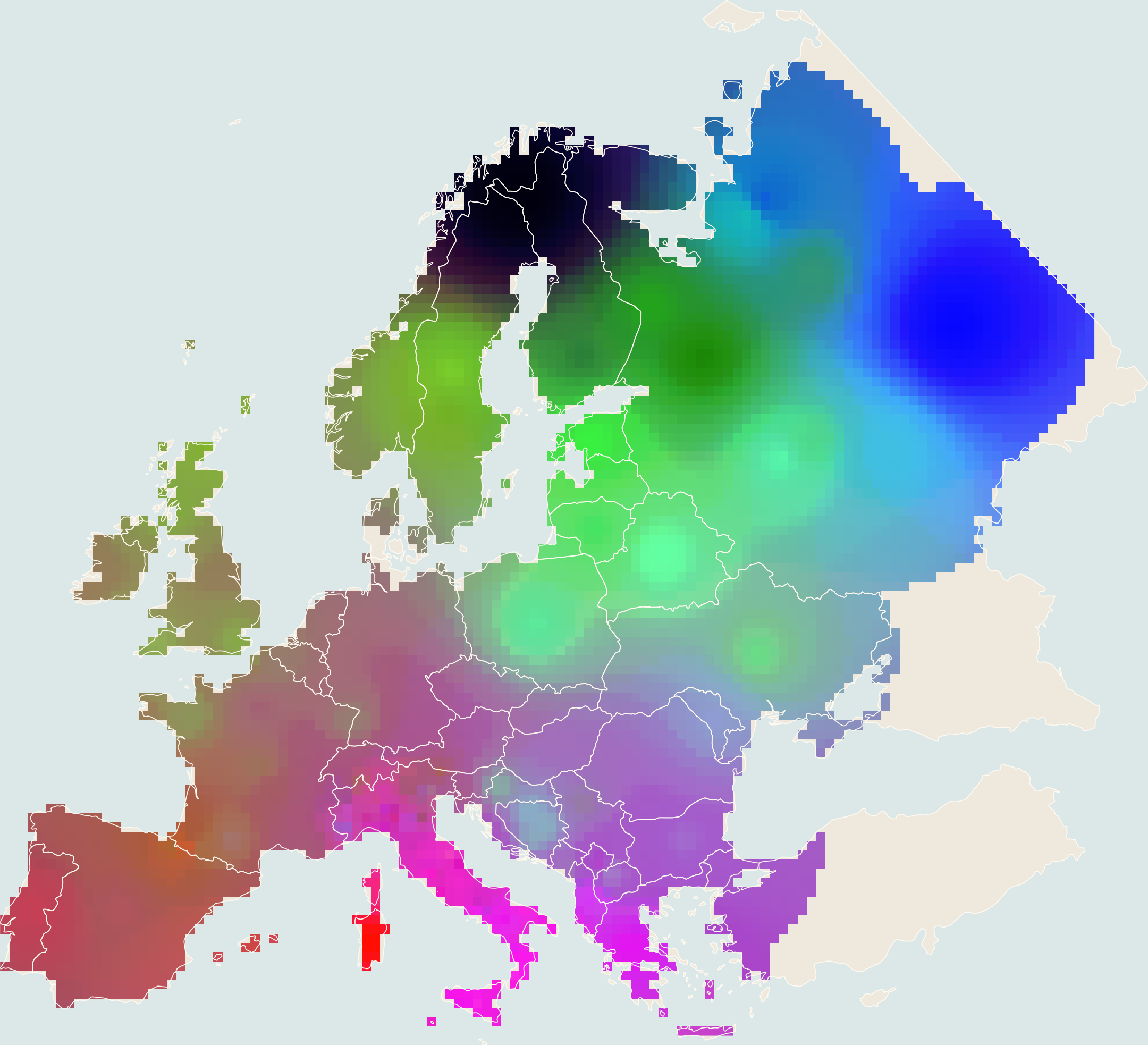
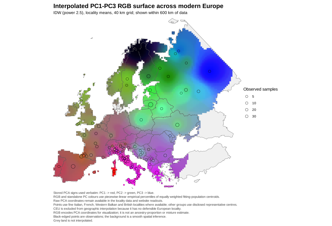
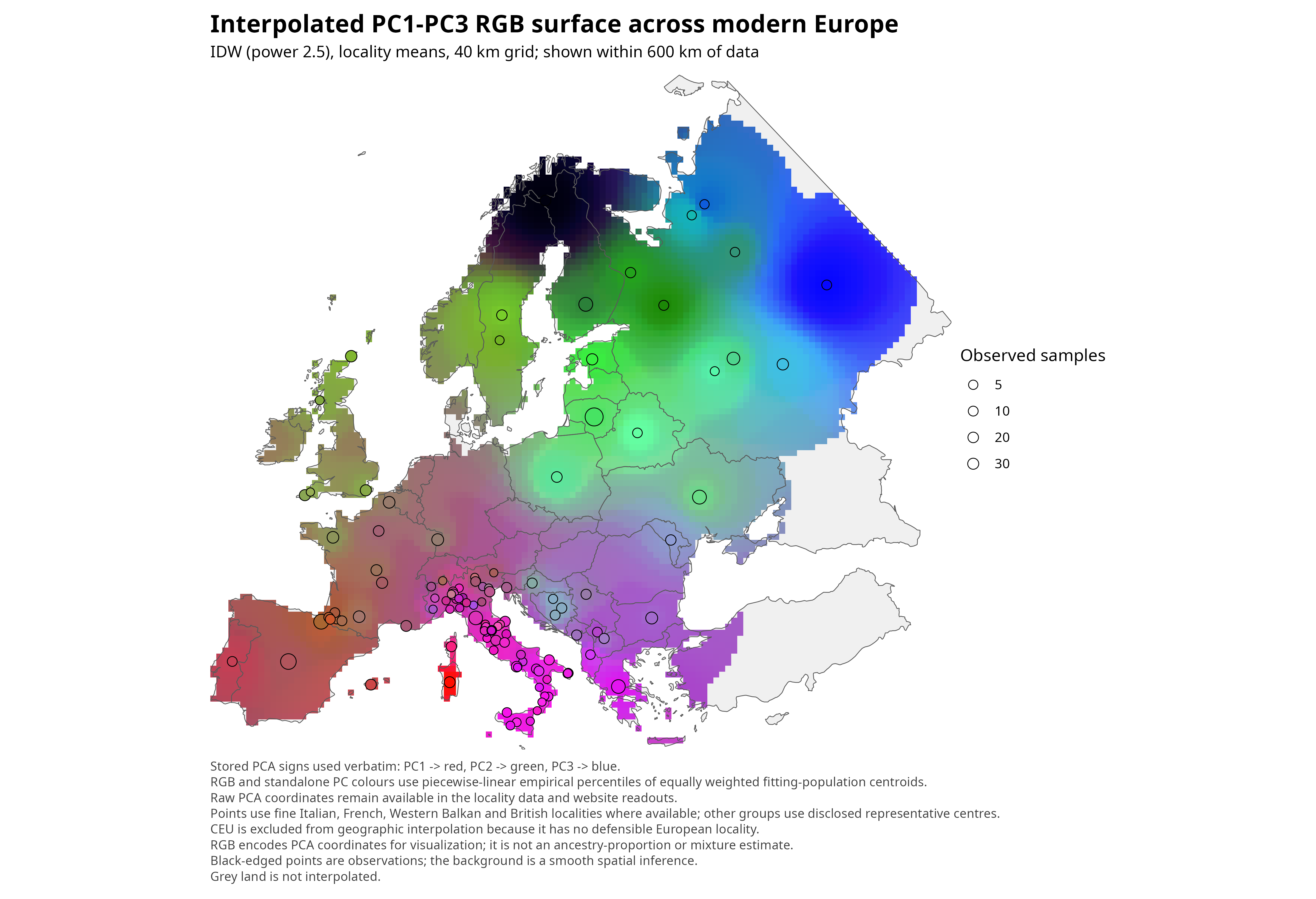
These maps revive the RGB “synthetic map” tradition. Each of the first three principal components is first converted into a separate intensity surface: PC1 controls red, PC2 green, and PC3 blue. The three surfaces are then superimposed pixel by pixel as the colour channels of one composite RGB map. Places with similar hues occupy similar positions across all three axes, while changes in hue let the eye follow multivariate clines, boundaries, and local deviations that would otherwise require comparing three separate maps. The composite is descriptive and model-dependent; it is not an ancestry calculator. Spain, the Europe-basis Great Britain view, and European Russia are country details of the Europe analysis. Britain also has a separate country-only PCA for greater within-country contrast. France and the Europe-inclusive Italy view use separate fine-geography bases.

Start with Europe ↓
Layer
Europe-wide PCAReliability-weighted population-centroid Europe-only PCA. Spain and European Russia inherit the Europe-wide colour scale; France and Italy use locally scaled fine-geography views. Zooming never changes coordinates.
Europe-wide PCA, RGB composite
RGB compositePC1 = red · PC2 = green · PC3 = blue

Individual PCA distribution

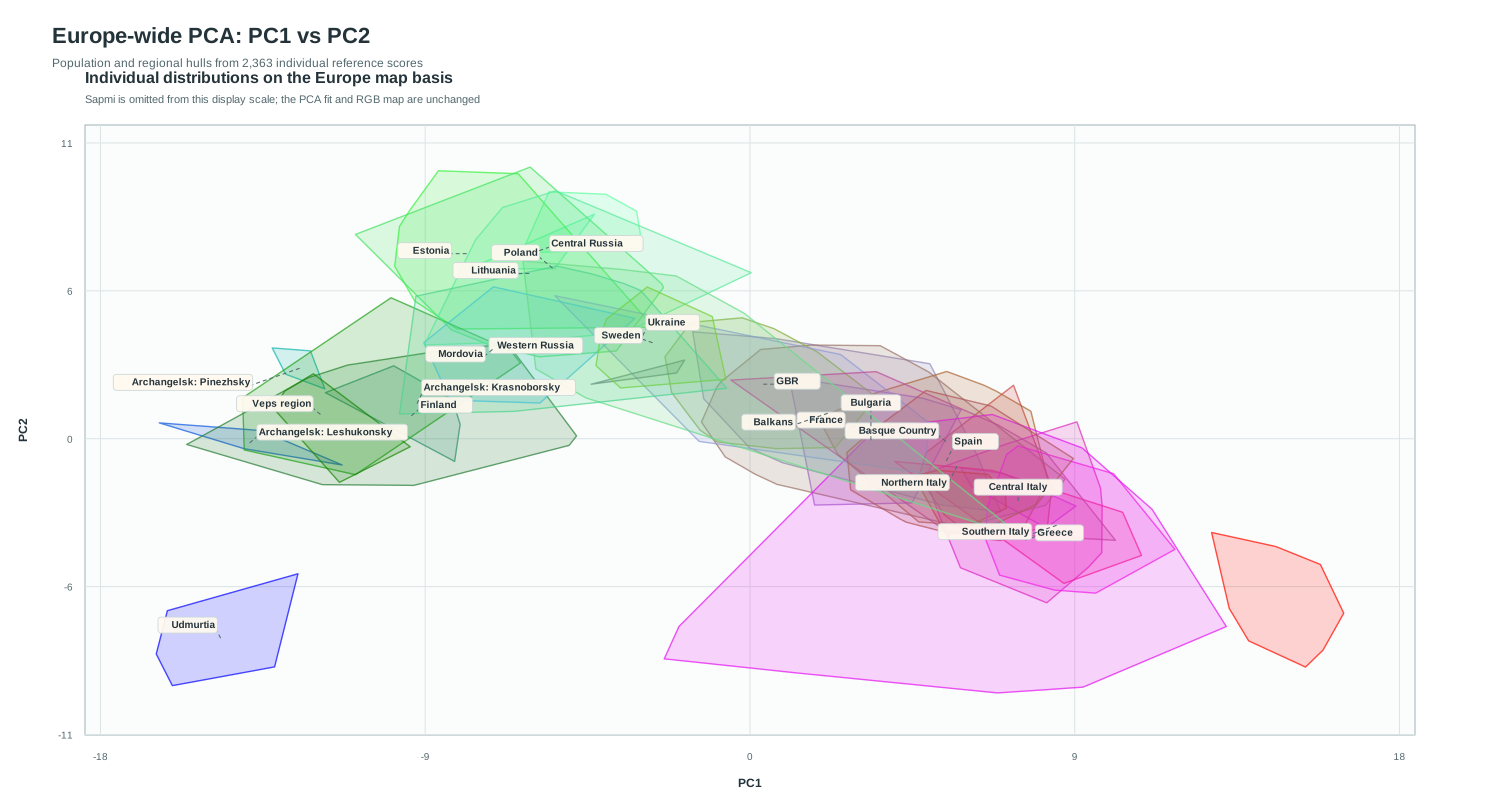
Population overlap on the Europe-wide PC1 and PC2

The plot shows 2,363 individual reference scores on the same reliability-weighted Europe-only PCA coordinates used by the RGB map. Countries are shown as country-scale distributions, while Italy is divided only into Northern, Central and Southern Italy.

Hover over a hull, or select a population to isolate it.

Loading interactive hulls…
The scatterplot and map share one PCA basis. TSI is grouped with Central Italy. Sapmi is omitted only from the displayed scatter scale because its extreme position compresses the rest of Europe; it remains part of the PCA analysis and RGB atlas map. My genome is not included in this figure.

Methods and boundaries

What the colours mean—and what they do not.

01

Calculate PCA

The Europe, France, and Europe-inclusive Italy bases fit reliability-weighted population means. The country-only Britain view fits every retained person simultaneously from its raw-genotype country panel while controlling each locality's total influence; nobody is held out.

02

Translate into colour

PC1 becomes red, PC2 green, and PC3 blue. Europe, Spain, and European Russia use equal-population empirical percentiles, so an extreme population cannot consume most of a channel. Great Britain, France, and Italy use explicitly labelled local contrast scales to reveal within-country variation. Britain-only uses individual-score 2.5th–97.5th percentiles. The three surfaces are then superimposed pixel by pixel. Colours preserve ordering within a PCA basis but are not linear PCA distances. Separate PCAs can rotate or exchange axes, so their RGB hues are not directly comparable.

03

Interpolate cautiously

A mapped location is a population or locality mean placed at a disclosed geographic point; it may be an exact collection locality or a clearly labelled representative centre. These observed means are interpolated over land. A country view requires at least three mapped locations and uses only those locations.

Interpretive boundary

Colours summarize PCA position and are not ancestry percentages. PC1 and PC2 are stable in the 30-replicate population-stratified bootstrap; Europe-only PC3 is exploratory and less stable. The Sámi PC2 shift persists after reliability weighting, but remains an axis-specific rather than whole-genome distance statement. The separate Italy fine-geography analysis displays the recovered Naples records alongside the audited Italian localities; Sardinia remains a disclosed population-level sensitivity anchor. Smooth transitions can reflect migration and isolation by distance, while sharp local contrasts may reflect drift or barriers—but the map alone cannot identify a historical cause.

Transparent calculation

How it was calculated—and who is represented.

Counts change when you switch analyses because each map has its own fitting panel and geographic eligibility rules. These categories are kept separate below.

2,492PCA fitting panel38 population labels
2,393Mapped individuals123 mapped locations
99Excluded from mapCEU only
8,180PCA markersLD-pruned autosomal SNPs

Exact sequence

Europe-wide PCA

  1. 01

    All eligible pre-cap references were intersected with the KING unrelated set, and all 348 curated Italian samples were added. Model-specific genotype QC excluded two all-homozygous encodings (HG00124.SG and NA20526.SG), leaving 2492 people in 38 European labels. All 107 1KG TSI are retained as a distinct fitting population.

  2. 02

    Every person was retained. Individual weight was 1/max(population N, 30), so a population's total influence is min(1, N/30): cohorts above 30 cannot dominate, while tiny groups are not amplified to full-population leverage. Axes were fitted to one mean standardized-genotype vector per population using 8,180 shared, LD-pruned autosomal SNPs.

  3. 03

    Italian, French, Western Balkan and British samples contribute through their controlled source-population groups; locality labels do not become extra PCA-fitting units. Fine geography is used for mapping wherever available. The 99 CEU references remain in the PCA but are excluded geographically, leaving 2393 people at 123 mapped locations.

  4. 04

    Population centroids set the robust colour limits, preventing the finer Italian, French, Western Balkan and British locality grids from determining the scale. Locality means are then interpolated by inverse-distance weighting (power 2.5) on a 40 km land grid within 600 km of observed data, with spatial influence multiplied by min(n, 5)/5.

  5. 05

    The 30-replicate population-stratified bootstrap gives median aligned correlations of 0.994 for PC1, 0.958 for PC2 and 0.652 for PC3. PC3 remains the least stable axis and should be treated as exploratory.

Population-level audit

Sample counts

All 38 PCA populationsFitting and mapped counts
Population labelScopePCA fittingMappedMapping status
AlbanianEurope77Mapped with fine locality detail where available; otherwise at a disclosed regional centre
BalearicEurope2525Mapped with fine locality detail where available; otherwise at a disclosed regional centre
BalkanEurope9494Mapped with fine locality detail where available; otherwise at a disclosed regional centre
BasquesEurope213213Mapped with fine locality detail where available; otherwise at a disclosed regional centre
BelarusianEurope88Mapped with fine locality detail where available; otherwise at a disclosed regional centre
BulgarianEurope5151Mapped with fine locality detail where available; otherwise at a disclosed regional centre
CEUEurope990Excluded: Utah CEU sample has no defensible single European locality
CorsicaEurope1616Mapped with fine locality detail where available; otherwise at a disclosed regional centre
EstoniansEurope3434Mapped with fine locality detail where available; otherwise at a disclosed regional centre
FinnsEurope116116Mapped with fine locality detail where available; otherwise at a disclosed regional centre
FrenchEurope284284Mapped with fine locality detail where available; otherwise at a disclosed regional centre
GBREurope9191Mapped with fine locality detail where available; otherwise at a disclosed regional centre
GreekEurope111111Mapped with fine locality detail where available; otherwise at a disclosed regional centre
IBSEurope202202Mapped with fine locality detail where available; otherwise at a disclosed regional centre
Italy_CEurope7373Mapped with fine locality detail where available; otherwise at a disclosed regional centre
Italy_NEurope9191Mapped with fine locality detail where available; otherwise at a disclosed regional centre
Italy_SEurope8989Mapped with fine locality detail where available; otherwise at a disclosed regional centre
KarelianEurope1717Mapped with fine locality detail where available; otherwise at a disclosed regional centre
LithuanianEurope352352Mapped with fine locality detail where available; otherwise at a disclosed regional centre
MoldavianEurope1818Mapped with fine locality detail where available; otherwise at a disclosed regional centre
MordovianEurope3737Mapped with fine locality detail where available; otherwise at a disclosed regional centre
NordicEurope33Mapped with fine locality detail where available; otherwise at a disclosed regional centre
OrcadianEurope1515Mapped with fine locality detail where available; otherwise at a disclosed regional centre
PolishEurope2222Mapped with fine locality detail where available; otherwise at a disclosed regional centre
PortugalEurope1010Mapped with fine locality detail where available; otherwise at a disclosed regional centre
ProvenceEurope55Mapped with fine locality detail where available; otherwise at a disclosed regional centre
RussianEurope7474Mapped with fine locality detail where available; otherwise at a disclosed regional centre
Russian_Archangelsk_KrasnoborskyEurope66Mapped with fine locality detail where available; otherwise at a disclosed regional centre
Russian_Archangelsk_LeshukonskyEurope55Mapped with fine locality detail where available; otherwise at a disclosed regional centre
Russian_Archangelsk_PinezhskyEurope55Mapped with fine locality detail where available; otherwise at a disclosed regional centre
Russians_CentralEurope33Mapped with fine locality detail where available; otherwise at a disclosed regional centre
SaamiEurope2323Mapped with fine locality detail where available; otherwise at a disclosed regional centre
SardinianEurope2828Mapped with fine locality detail where available; otherwise at a disclosed regional centre
SwedishEurope1919Mapped with fine locality detail where available; otherwise at a disclosed regional centre
TSIEurope107107Mapped with fine locality detail where available; otherwise at a disclosed regional centre
UdmurtEurope1010Mapped with fine locality detail where available; otherwise at a disclosed regional centre
UkrainianEurope117117Mapped with fine locality detail where available; otherwise at a disclosed regional centre
VepsEurope1212Mapped with fine locality detail where available; otherwise at a disclosed regional centre

Population names are source-dataset labels. Italy, France, the Western Balkans and Britain use fine localities where available; remaining samples use disclosed representative centres.

Open materials

Download this analysis

All eligible unrelated references plus all 349 directly available raw Italian samples; France, Italy, the Western Balkans and Britain contribute through controlled source-population groups. Fine localities are mapping units only. Stored PC signs; equal-population empirical-percentile colour scaling for RGB and individual PC layers; sample-size-reliability-weighted IDW on a 40 km grid within 600 km of data (full locality weight at n = 5).